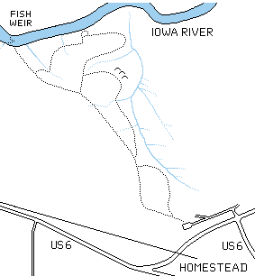
The Amana Nature Trail is a system of three trail loops between US 6 and the Iowa River on private land just north of Homestead, Iowa. The longest trail loop is over 3 miles long, and it is open to hiking and cross-country skiing.
To reach this area, go west on US 6 to Homestead Iowa (the southeasternmost of the Amana Colonies), and then, where US 6 turns left at a T intersection with US 151, go straight across the intersection onto a gravel drive. There is a sign saying "Nature Trail" at that point. The gravel drive splits in a T intersection; turn left and follow the road to a small parking area for the trail head.
There is a picnic shelter at the trailhead parking lot
The trail begins in a wooded pasture, but after a short walk, the trail crosses the edge of the pasture and enters a mature commercial forest. Trees have been cut here by the Amana Society for a century, and the trail is built on a logging road that is still in use.
The ongoing logging activity has, if anything, produced an improved environment for many woodland wildflowers and shrubs, opening up the forest canopy and letting in the sun, without changing the overall woodland character of the area. The downside of this activity is that there are few mature trees and there is little standing deadwood; this limits the nesting opportunities for woodpeckers and other cavity nesting birds.
Although it is sometimes subtle, evidence of logging activity is everywhere, from the roads themselves to stumps and paint marks on trees scheduled for cutting. The stumps are in every stage of decay from ancient mounds of rotten wood to freshly cut, and there is generally a brush pile near each freshly cut stump, made of the branches that were stripped from the tree prior to hauling away the logs.
The erosion of the Iowa River Valley has exposed some large glacial boulders along the trail. These were brought into the area during the ice ages, during one of the pre-Illinoisian glacial advances (perhaps half a million years ago; note that no glaciers reached this part of Iowa during the more recent glacial advances).
Finally, there is interesting archeological sites along the trail. There is a trio of indian burial mounds near the trail, probably dating from the Early Woodland period, about 1000 years ago, and at the end of the trail, there is a fish weir, a V-shaped array of rocks placed there by American Indians as a fish trap. This fish weir is on the National Register of Historic Places, and it is the only structure of this kind in Iowa.
At high water, this structure is entirely under water, but at low water, the rocks are clearly visible. In operation, presumably, fish would be herded through the shallow water toward the vertex, of the V, perhaps by people beating the water with branches. Once trapped in the shallow water of the vertex, it would be quite easy to net or spear the fish.
In the spring, this area puts on a spectacular wildflower display, and it is a good site for birdwatching, spring and fall. The trail is open for hiking and cross country skiing, but is closed to all activity during Iowa's shotgun deer season.
Note that the trail is only open to non-consumptive use. Mushroom hunting, nutting and wild berry collecting on this land require a special permit.
As a commercial forest, the largest threat to this area is from changes in forestry practices. The successful balance demonstrated over the past century between a sustained commercial yield and the maintenance of the natural character of the area does not imply that a change in the management of the area will necessarily be a threat, but the success of past management practices does suggest that any new approach to managing the area should be carefully examined.
The ongoing lumbering activity does lead to some erosion problems, particularly where logs are skidded across wet areas. These mud holes are highly localized, and they do not appear to be sources new gully erosion, probably because most of the timber hauling occurs when the ground is frozen.
In warm weather, off-trail pedestrian traffic may pose a significant erosion threat, but there is little evidence that this has become a problem in this area, except in the immediate vicinity of stream crossings. The small pedestrian bridges being put in by the Amana Society Corporation and the local Boy Scout troop appear to be the appropriate solution to this problem.
The Amana Nature Trail is managed by the Amana Society Forestry office, (319)662-7554.
The map at the head of this section is based on an annotated aerial photo provided by Larry Gnewikow of Amana Society Forestry.